
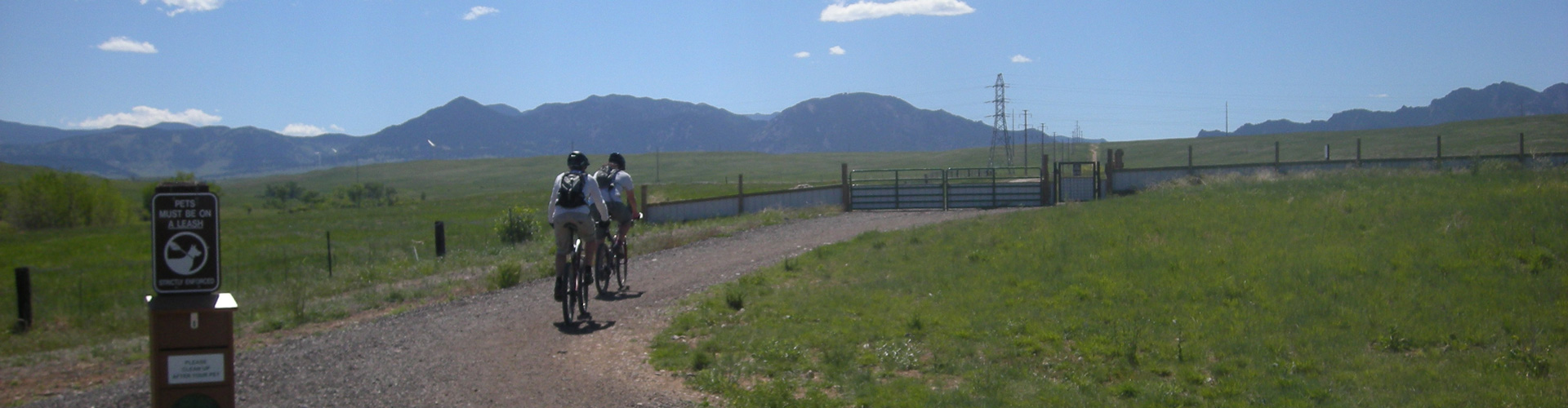
Enjoy rolling hills, open plains vistas, and grasslands habitats.
Coalton Trailhead
Trails
-
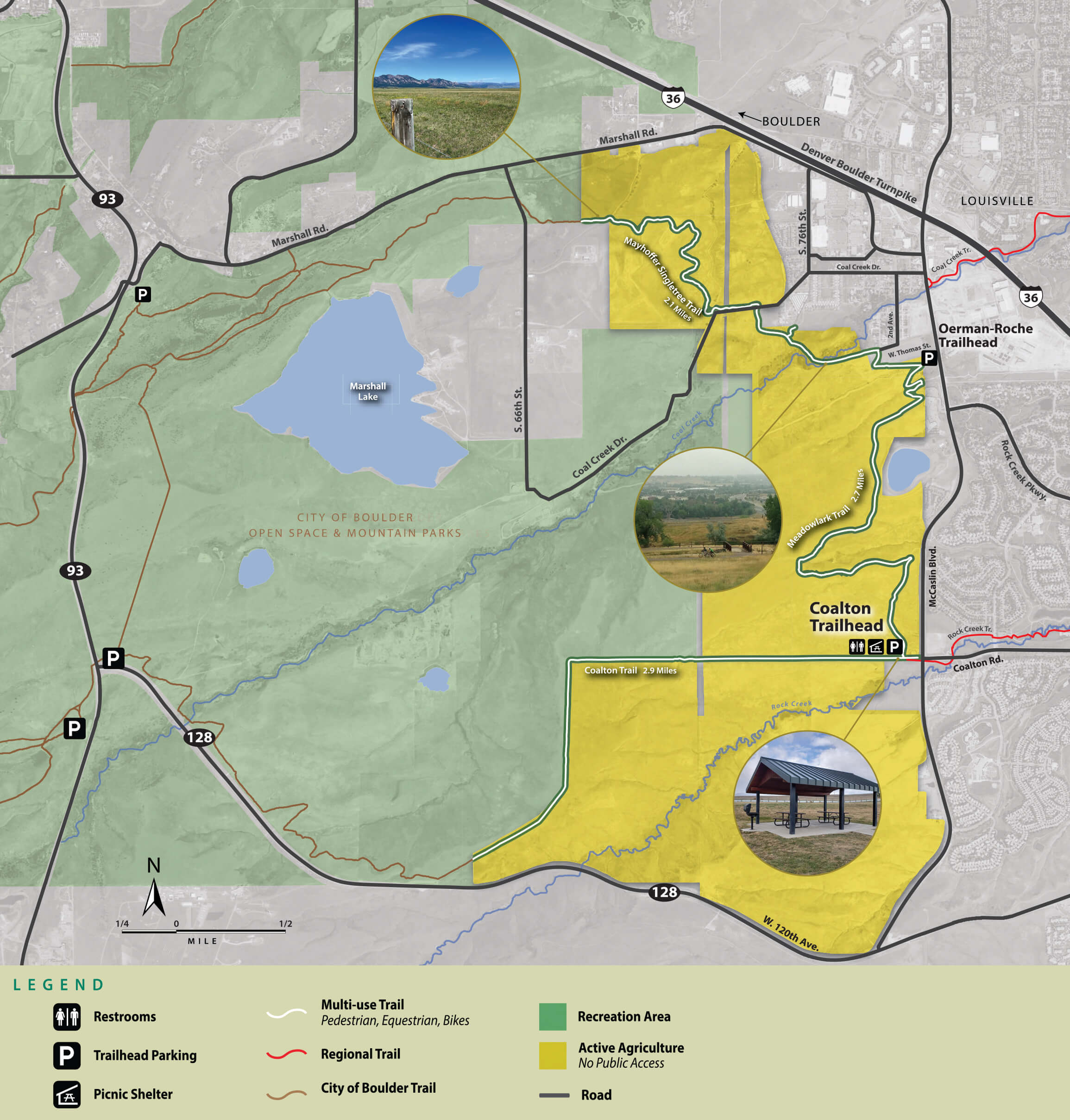
Coalton Trail
2.9 miles – Easy


-
Mayhoffer Singletree Trail
2.1 miles – Easy -
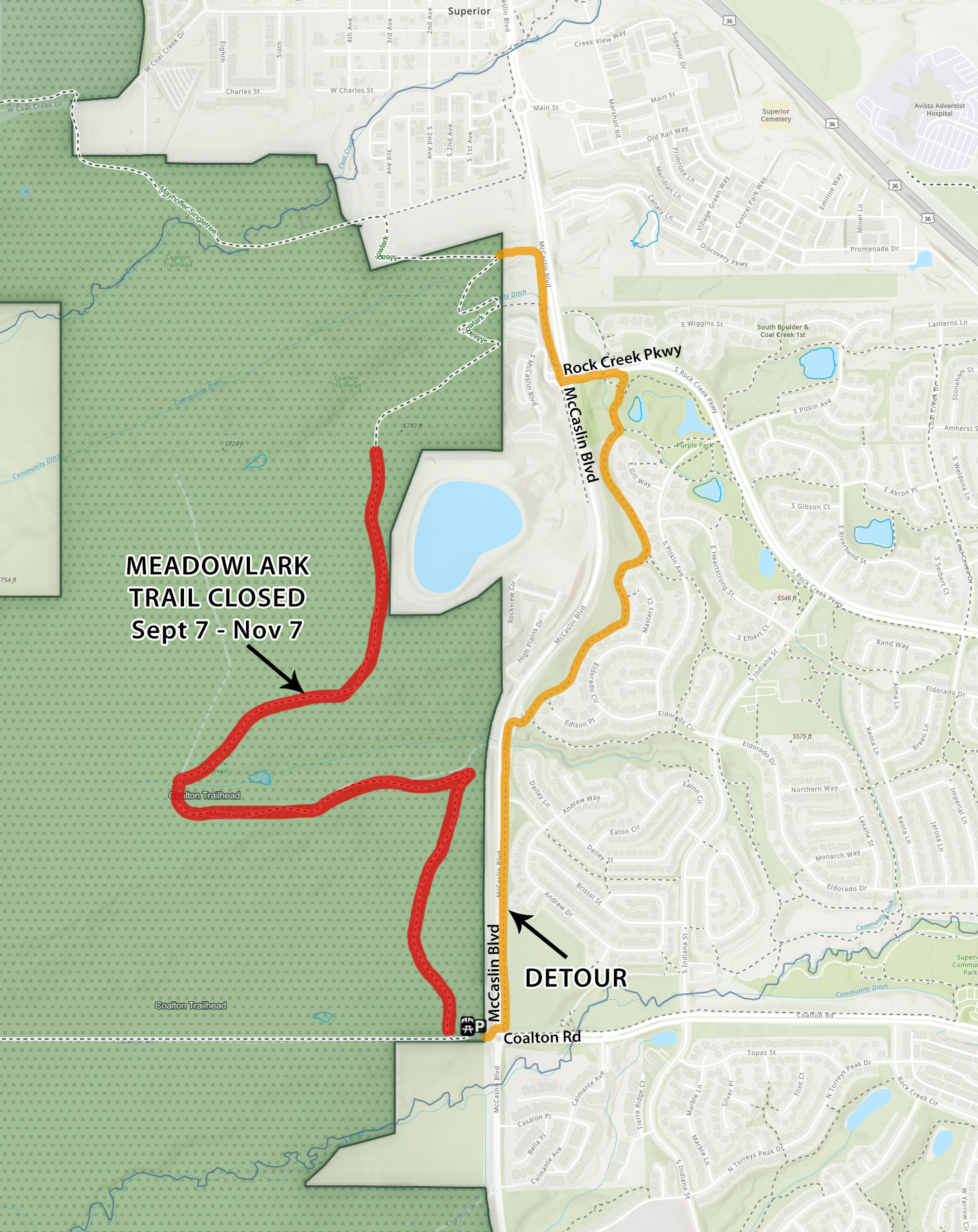
Meadowlark Trail
2.7 miles – Easy
Trails Connections
- Coal Creek Trail
- Rock Creek Trail
- Cowdrey Draw Trail (managed by the City of Boulder)
- High Plains Trail (managed by the City of Boulder)
- Marshall Mesa Trailhead (managed by the City of Boulder)
- Greenbelt Plateau Trailhead (managed by the City of Boulder)
Rules and Regulations

Bikes On Designated Trails Only
Pets On Leash
No Drones

No Hunting/Firearms
No Camping
Trailhead Amenities

27 car parking spots

2 ADA parking spots

Restroom near trailhead

20 person group shelter located near trailhead

3 horse trailer parking spots
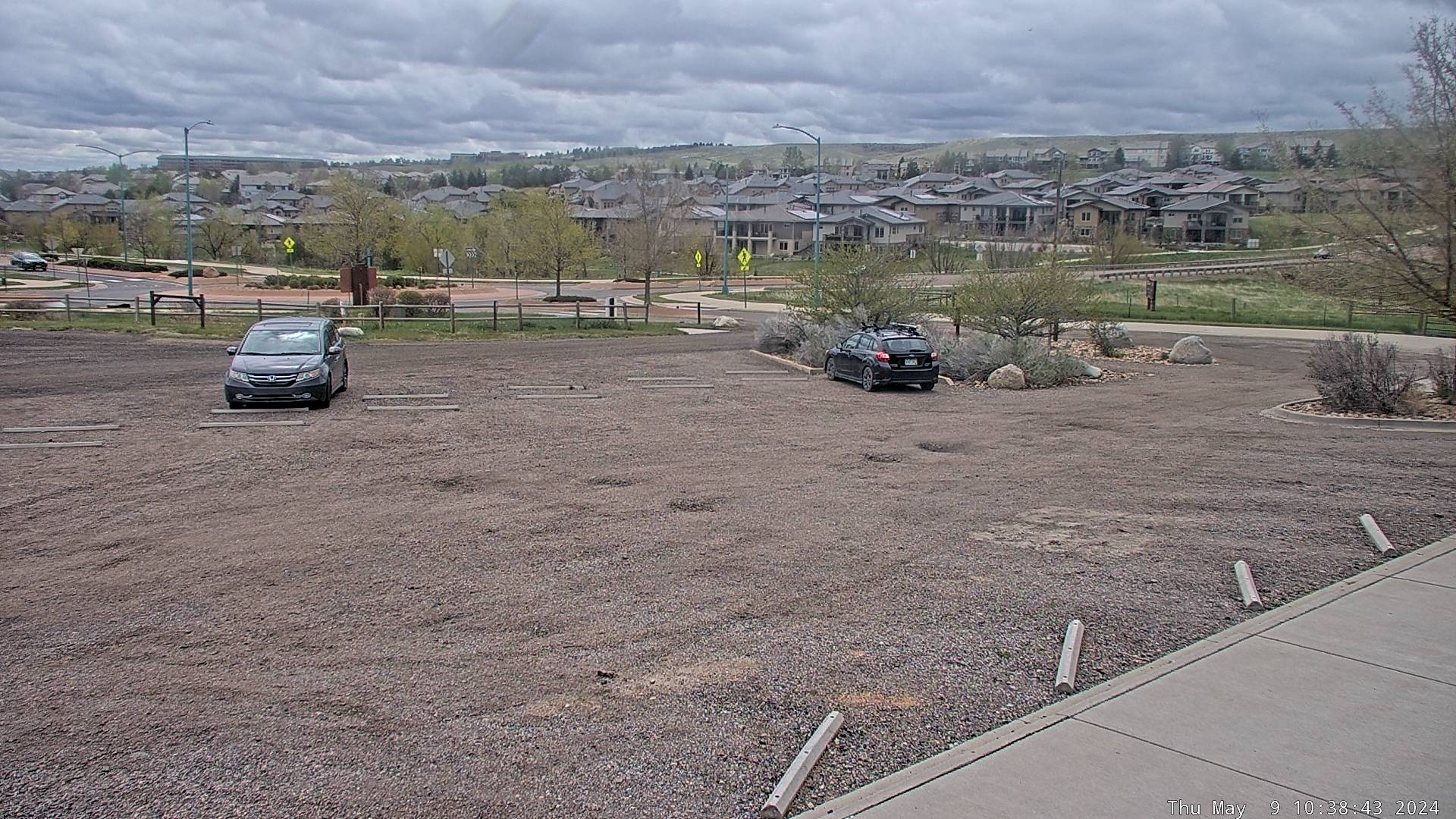
Live view of the Coalton Trailhead Parking Lot. More images below.
Keep in Mind
- Pedestrians, bicyclists, equestrians, and leashed dogs are allowed on the trails.
- The trails travel through active agricultural land and off-trail access is not permitted.
- Livestock may be present along trails and can be aggressive. Please move slowly and allow livestock to move off the trail.
- Additional parking is available at the Oerman-Roche Trailhead, 1.5 miles north of the Coalton Trailhead on McCaslin Blvd.
- Regional trails and regional trail connectors are open to commuters 24 hours per day. Trailheads close at sunset and parking is not allowed between sunset and sunrise.
Photos
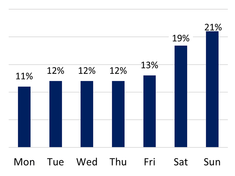
Open Gallery in New WindowVisitation by Day of Week
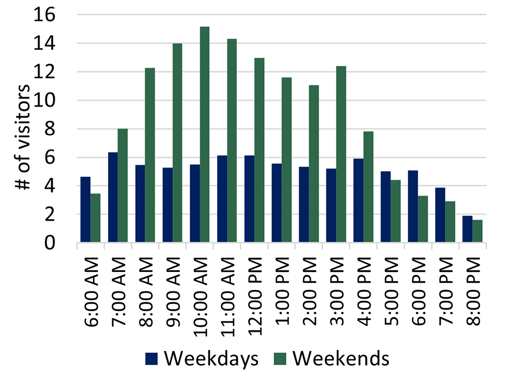
Visitation by Hour
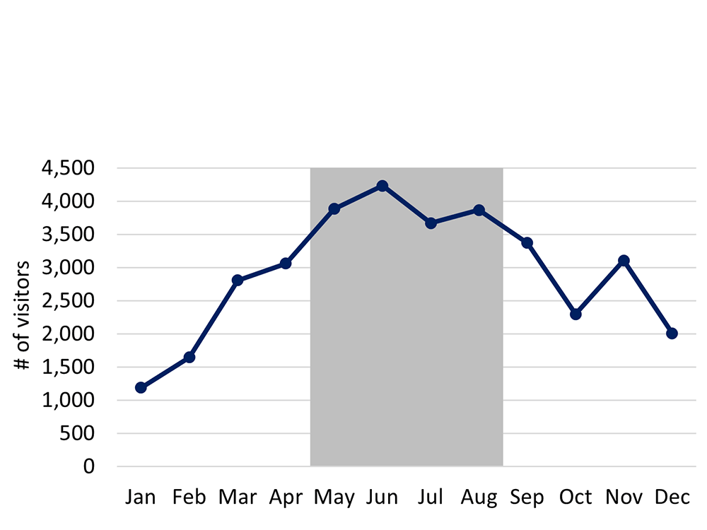
Visitation by Month
In the rain shadow of the Rocky Mountains, the Great Plains are dry, windy and expansive. Receiving small amounts of precipitation, the land is dominated by grasses. The scarcity of water prevents larger shrubs and trees from growing. However, the soils are rich thus allowing a wealth of smaller plants to thrive. These plants, in turn, support a variety of animal species. Temperatures on the plains fluctuate enormously from very cold winters to hot summers. Nevertheless unique plant and animal adaptations have allowed life to prosper in plains ecosystems.
Mammals
- Black-tailed prairie dog
- Bobcat
- Coyote
- Deer mouse
- Little brown bat
- Mule deer
- Nuttall’s cottontail
- Raccoon
- Red fox
Birds
- American crow
- American kestrel
- American robin
- Barn swallow
- Black-billed magpie
- Chipping sparrow
- Common raven
- Common grackle
- Eastern kingbird
- Mourning dove
- Red-tailed hawk
- Red-winged blackbird
- Rock dove
- Song sparrow
- Turkey vulture
- Western kingbird
- Western Meadowlark
Amphibians and Reptiles
- Bullsnake
- Prairie rattlesnake
- Short-horned lizard
- Chorus frog
- Northern leopard frog
Insects
- American bumblebee
- Blister beetle
- Boxelder bug
- Carolina grasshopper
- Clouded sulphur butterfly
- Colorado soldier beetle
- Darkling beetle
- Gray hairstreak butterfly
- Green-striped grasshopper
- Hunt’s bumblebee
- Painted lady butterfly
- Plains lubber grasshopper
- Skipper butterfly species
- Speckle-winged rangeland grasshopper
- Twelve-spotted skimmer dragonfly
Shrubs
- Boxelder
- Chokecherry
- Coyote willow
- Sand cherry
- Wild plum
- Wild rose
Trees
- Boxelder
- Chokecherry
- Coyote willow
- Sand cherry
- Wild plum
- Wild rose
White/light pink wildflowers
- Deathcamas (Toxicoscordion sp)
- Downy paintbrush (Castilleja sessiliflora)
- Drummond’s milkvetch (Astragalus drummondii)
- Great plains yucca (Yucca glauca)
- Ground-plum (Astragalus crassicarpus)
- Narrow leaf puccoon (Lithospermum incisum)
- Prickly poppy (Argemone polyanthemos)
- Sand lily (Leucocrinum montanum)
- Scarlet beeblossom (Oenothera suffrutescens)
- Snow-on-the-mountain (Euphorbia marginata)
- Textile onion (Allium textile)
- Wedgeleaf frogfruit (Phyla cuneifolia)
- Western false gromwell (Lithospermum occidentale)
Yellow/green wildflowers
- Blanketflower (Gaillardia aristata)
- Buffalo-bur (Solanum rostratum)
- Coneflower (Ratibida sp)
- Cowpen daisy (Verbesina encelioides)
- Curlycup gumweed (Grendelia squarrosa)
- Evening primrose species (Oenothera sp)
- Goldenrod (Solidago sp)
- Hairy false goldenaster (Heterotheca villosa)
- Leafy wildparsley (Musineon divaricatum)
- Narrowleaf puccoon (Lithospermum incisum)
- Nuttall’s violet (Viola nuttallii)
- Plains coreopsis (Coreopsis tinctoria)
- Prairie false dandelion (Nothocalais cuspidata)
- Prickly pear cactus (Opuntia sp)
- Wild sunflower (Helianthus annuus)
Blue/Purple/magenta wildflowers
- American vetch (Vicia americana)
- Blue flax (Linum lewisii)
- Britton’s skullcap (Scutellaria brittoni)
- Dakota mock vervain (Glandularia bipinnatifida)
- Dotted gayfeather (Liatris punctata)
- Early purple milkvetch (Astragalus shortianus)
- Locoweed (Oxytropis sericea and O. lambertii)
- Narrow leaf penstemon (Penstemon angustifolius)
- Pleated gentian (Gentiana affinis)
- Prairie bluebells (Mertensia lanceolata)
- Purple prairie clover (Dalea purpurea)
- Rocky mountain beeplant (Cleome serrulata)
- Sidebells penstemon (Penstemon secundiflorus)
Red wildflowers
- Scarlet globemallow (Sphaeralcea coccinea)
This loop, formed by Boulder County and City of Boulder trails, is the former route of the Morgul-Bismarck Loop of the Coors International Bicycle Classic from the 1980s and is commonly referred to as the Dirty Bismark Loop.