March 28, 2025
Agriculture Prescribed Burns Near Superior and Louisville Planned for March 31-April 4
Ditch burns scheduled near Superior and Louisville
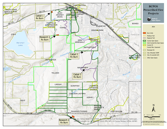
Boulder County Parks & Open Space and the Sheriff’s Office Fire Management Program will conduct agricultural burns Monday through Friday, March 31 through April 4, as conditions allow. Five projects are planned, all less than 2.5 acres. These projects are being conducted for research purposes and to remove unwanted vegetation. The cattail burns are expected to produce a lot of dark smoke.
The locations include the following and are indicated on the map below:
- Mayhoffer (Cattail 2 & 3): McCaslin Blvd., Superior
- Cohig (Research 1): Coal Creek Dr., Superior
- Zaharias-Thomas (Research 2): McCaslin Blvd. and SH 128, Superior
- Bush (Cattail 1): Coal Creek Dr., Superior
Burn projects depend on ideal weather conditions, including relative humidity, fuel moisture, and wind. Projects will only proceed when conditions are suitable. Fire managers will monitor all projects until they are called out.
Smoke from prescribed fires may affect health. The Colorado Department of Public Health & Environment Wood Smoke and Health webpage and the Boulder County Public Health Wildfire Air Quality & Health webpage provide tips on how to protect health from smoke.
A full list of burn areas and timing updates are posted on boco.org/PrescribedBurns.
Questions? Contact Boulder County Parks & Open Space Forestry and Fire Group at BCForestry@bouldercounty.gov.