Read the commissioners’ update about Xcel’s Power Outage.

CO 7 Bus Rapid Transit Study & Development

Colorado State Highway 7 (CO 7) Bus Rapid Transit (BRT) Development

State Highway 7 BRT Study area map and timeline
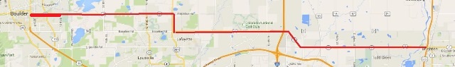
In conjunction with collaborating partners, Boulder County is assisting with the development of bus rapid transit along the Colorado State Highway 7 (CO 7) corridor to eventually extend from Brighton to Boulder. This project started with the Northwest Area Mobility Study and has included the development of a Planning and Environmental Linkages (PEL) study from Brighton to Lafayette, another PEL from Lafayette to Boulder and the Boulder East Arapahoe Plan within the city of Boulder. The project is in the Preliminary Engineering phase and is being managed by CDOT. The CO 7 Coalition approved moving forward in January 2021 using a Corridor Development Plan, which establishes the overall framework for which components on the corridor move into preliminary engineering and develops a schedule for when each component will be completed.

Photo showing an example of a queue jump lane at an intersection
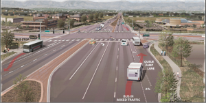
These studies have focused on how to accommodate future projected growth along the corridor and increase options for the traveling public. Bus Rapid Transit is an important part of recommendations and includes a variety of treatment options, including queue jump lanes and transit signal priority. This image shows an illustrative example of an intersection with queue jump lanes for transit with a widened intersection.

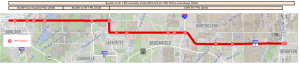
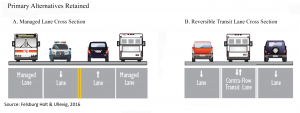
In an effort to help maintain a rural character, the section within Boulder County from US287 to 75th Street looked for alternative roadway cross sections that did not add additional general-purpose travel lanes to help keep the roadway narrow. The two retained alternatives (see below) provide example cross sections. Alternative A conceptually shows how the bus may be able to use an outside lane. The second alternative, B, shows a reversible transit lane, which would require use of technology to assist with timing the transit vehicles travel through the shared section.

Diagram showing two alternatives to adding additional general-purpose traffic lanes

Station Areas Planning

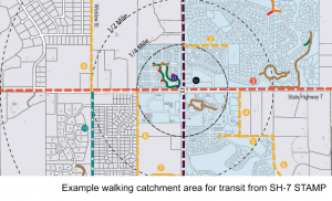
An important part of having excellent transit service also includes the environment to and around the stations. In an effort to help enhance the experience of people who choose to take transit, the county was also a part of Station Areas Master Plan (STAMP) project team. That project looked at the stations all the way from Brighton into Boulder.

Example of walking catchment area for transit from SH-7 STAMP

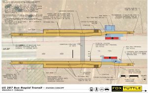
The county has also worked with the Town of Erie and others in determining potential conceptual station designs for the area near US 287 and Arapahoe. Spurred on a development proposal, multiple stakeholders came together to analyze various options for a station that would accommodate future transit enhancements while also determining the amount of right-of-way that would be needed. The full memo can be found here.

The image below shows a station area concept for US 287 and Lucerne Drive with enhanced bus bays, amenities, and a pedestrian tunnel. This option will move forward for further analysis.

Diagram showing concept for RTD station area at US287 and CO-7

Project Contact

Boulder County Senior Transportation Planner, Landon Hilliard

CO-7 Bus Rapid Transit (BRT) Study

Previous Public Meetings

  • April 26, 2017 – Public Meeting to Share Information & Collect Input on Recent Studies

The Transportation Department hosted a public meeting to provide information and gather feedback on recent studies undertaken to better understand current and future conditions on Arapahoe Road/SH 7 between 75th Street and US Highway 287. Meeting attendees:

  • Learned more about the Bus Rapid Transit (BRT) Feasibility Study (available below)
  • Learned more about and provide feedback on the SH 7 (75th to US 287) Planning & Environmental Linkages (PEL) Study that will identify future transportation improvements along this important corridor
  • View the presentation – Please note that due to animations in the presentation, this file is very large and may take some time to open.
  • View the meeting boards

Background:

Two studies from 2014 – one conducted by the State (CDOT’s SH 7 Planning & Environmental Linkages Study) and one by RTD (the Northwest Area Mobility Study) – identified necessary traffic/travel improvements along the State Highway 7 (SH 7) corridor between the City of Boulder and the City of Brighton. They also showed that projected traffic volumes and expansion plans by communities along the corridor suggest that SH 7 may be a strong candidate for the implementation of Bus Rapid Transit (BRT) service. The project area is shown in the map below – the red line is SH 7.

State Highway 7 BRT Study area map

Purpose of the Study:

  1. To look into CDOT’s analysis and recommendations for SH 7
  2. Investigate the feasibility of BRT on SH 7 and develop a cohesive operations plan for the corridor.
  3. Conduct a connectivity analysis to other elements of RTD’s transit system, including FasTracks and regional transit routes.

Objectives:

To seek to address current and future traffic issues on SH 7 as it is anticipated that significant growth in the project area will result in the need to move more people through the corridor more efficiently.

To proactively develop a BRT system in advance of seeing a fully built-out land use scenario, because creating this plan now will ensure that development and corridor enhancements take place with a BRT system in mind. Learn more about Bus Rapid Transit.

Study Partners & Work Plans:

The study is truly regional in nature as it covers three counties, six communities, and two CDOT regions. The success of this study absolutely depends upon the collaboration, involvement and support of all jurisdictions along SH 7. The project was awarded grant funds by the Denver Regional Council of Governments (DRCOG) and matching funds will be provided by Boulder and Adams counties. View the grant application. The study implementation is being led by Boulder County.

To guide the work, a Transportation Advisory Committee (TAC) has been assembled by planning staff representing corridor communities, county governments, CDOT staff, RTD, DRCOG, the Federal Highways Administration (FHWA), and the Federal Transit Administration (FTA).

The TAC will review project work, provide feedback and guidance, and make recommendations to a Policy Advisory Committee (PAC).

The PAC will weigh-in on and provide final guidance and approvals for the SH 7 BRT Study. This group is comprised of members of the Highway 7 Coalition (leaders and decision-makers from corridor municipalities), county governments, CDOT, RTD, and DRCOG.

Community Profiles & Their Thoughts on Future of SH 7 Corridor:

SH 7 BRT Feasibility Study

This study, completed in 2018, addresses the increased trip demand on SH7 by assessing the feasibility of BRT on the corridor.

The State Highway 7 (SH 7) corridor between Brighton and Boulder is well positioned to develop as a corridor of local livability and multimodal regional access. This is due in large part to the attraction of the well-established downtown areas of Brighton, Lafayette and Boulder coupled with large areas of undeveloped parcels in unincorporated areas of Adams and Boulder Counties, Lafayette, Erie, Broomfield, Thornton and the east side of Brighton.

Combine these land use opportunities with the strategic location of SH 7 in the regional transportation network, and regional Bus Rapid Transit (BRT) has been deemed an effective mobility solution to serve local and regional transportation needs. SH 7 corridor communities are intentionally planning for BRT to enhance quality of life and connect communities with a safe, fast, and reliable transit system on a vibrant multimodal corridor.

As local jurisdictions strategically plan for transit-supportive development, it is crucial to integrate future access to stations via Park-N-Ride, local bus service, connected bikeways, trails and walkable neighborhoods. These efforts will complement the existing downtown areas and help to construct the crucial multimodal transportation networks necessary to build a transit ridership base.

The opportunity to create a more sustainable multimodal vision for SH 7 is now. If proactive measures are not implemented as the corridor develops, the quality of life and transportation options for existing and future residents and businesses along SH 7 will be limited. Investing in multi-modal infrastructure concurrent with new development, infill and redevelopment, is the most cost-effective strategy to achieve this vision.

State Highway 7 BRT Study Partners

State Highway 7 BRT Study Partners

Contact Us

Community Planning & Permitting (formerly the Land Use Dept.)

Email: Ask a Planner Form
Main: 303-441-3930

Courthouse Annex Building

2045 13th St.
Boulder, CO 80302

Hours

8 a.m. to 3 p.m. Monday, Wednesday, Thursday
10 a.m. to 3 p.m. Tuesday
Map and Directions

Mailing Address

Community Planning & Permitting
PO Box 471
Boulder, CO 80306
Community Planning & Permitting website