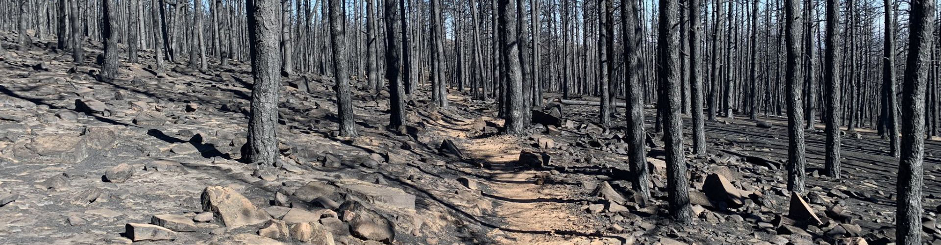
Recovery work is mostly complete at Heil Valley Ranch from the devastating Cal-Wood Fire.
Heil Valley Ranch Cal-Wood Fire Recovery
Completed Operations
- Hazard tree removal.
- Aerial mulching.
- Erosion and debris mitigation.
- Tree planting.
- Installed temporary bridges.
- Replaced damaged fencing, parking stops, signs, and other visitor amenities and park infrastructure.
We ask that visitors remain alert to falling trees and stay on cleared trails whenever possible. Fire deforestation has made this park even more wind-prone than before, and wind continues to fell weakened trees in the burn area.
Ongoing Operations
Work in 2023 will include the following:
- Installation of permanent bridges at the main trailhead.
- Completion of parking stall replacement at the main trailhead.
- Wapiti trail reroute planning and construction.
- Completion of additional parking lot near the south entrance to Heil Valley Ranch.
- Continued monitoring of snow melt events and rain events with the potential for park closure should there be advance warning of potential debris flows and flash floods.
- Continued maintenance of access roads, trails, and trailheads after damaging snow melt and rain events.
- Forest disease and insect control monitoring and treatment.
- Weed management.
- Debris flow clean-up and erosion repair as needed.
Cal-Wood Fire
The Cal-Wood Fire started on Oct. 17, 2020, and raced downwind and downslope through Heil Valley Ranch. It consumed 5,000 acres in about five hours. In the end, it covered over 10,000 acres with more than half of that on Boulder County owned property (4,400 acres) and conservation easements (1,400 acres).
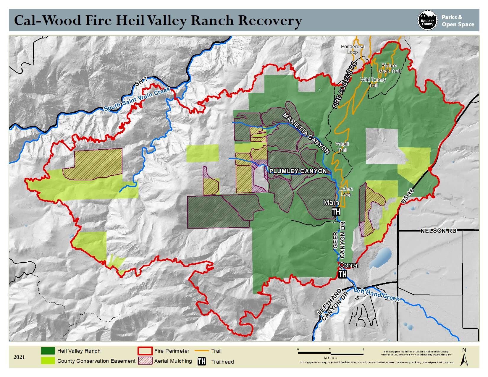
Maps
Safety Hazards in Closed Areas
We ask that all visitors remain on trail and be respectful of the closures due to safety hazards in the burn areas.
Falling Trees
Falling trees are a serious hazard. While hazard trees have been removed from the trail corridors of open trails (see details below), there are still lots of trees in the closed areas that could fall at any time, especially during windy conditions. People also can get injured by stepping into holes left behind after the trees (both trunks and roots) burned and/or fell.
Flooding
Flash floods are a real concern in burn areas. Although vegetation growth has been substantial in many areas, the severely burned landscape is still at risk to flood all small and large canyons (depending on where rainfall occurs) and deposit tons of debris and mud in many downstream/downslope areas.
Note: The main trailhead can see floods coming from the north and debris flows coming from the west or east, as well as possible floods cutting off escape routes in the south.
The risk of flash flooding with associated debris flows and mud flows is increased by soils previously saturated by snow or smaller rain events. The combination of conditions that can trigger a debris flow can make them unpredictable. Saturated soils are more common in the spring, and afternoon thunderstorms are common during the monsoon season (approximately June 1 through Sept. 30).
Flooding could occur in Left Hand Creek all the way to Longmont and beyond. Discolored, muddy, sediment-laden, and/or ashy water is expected and water may have higher levels of certain contaminants than normal runoff.
We have seen rain events as small as 0.35 inches in 15 minutes or 0.75 inches in one hour causing alarming flash floods at Heil Valley Ranch. We have been lucky because to this point the rainstorms have been of short duration. We expect this year it may take a larger rain event to cause substantial damage, particularly after the infrastructure protection implemented by the County and its partners in 2021 and 2022. However, no one controls the weather and we ask everyone to be cautious and quickly climb (not drive) to higher ground when intense rainfall is occurring nearby — especially if you hear large rumbling sounds which could be many boulders and trees tumbling down the canyons. In this watershed, driving will tend to put you at a lower elevation and therefore at higher risk.
Floods tend to be quick so please follow the signage and climb to higher ground and wait for rescue if you cannot safely return.
Recovery Plan
Trail Work
Conditions will be monitored after precipitation events for any erosion or debris deposition on trails.
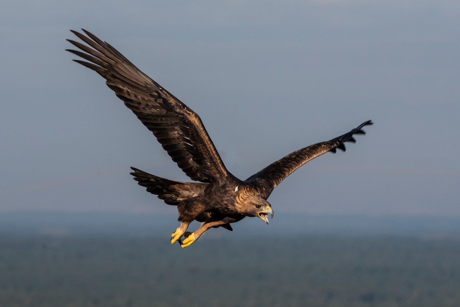
Wapiti Trail Detour Due to Wildlife Concerns
Boulder County works with Colorado Parks and Wildlife and the U.S. Fish and Wildlife Service (USFWS) to ensure protection of sensitive species. Staff follows federal guidance, such as the Bald and Golden Eagle Protection Act, when planning restoration and/or recreation activities.
During the 2020/2021 nesting season, one of the golden eagle nesting pairs in the fire area completely rebuilt their burned nest and successfully fledged one young. Boulder County biologists worked with USFWS to develop a strategy to protect the Heil Valley Ranch eagles during many months of intensive recovery operations. Staff and contractors avoided the critical half-mile zone around the nest, and instituted measures effecting the timing and approach to work: No-fly zones for helicopter mulching were delineated to protect the space around the nest, weekly observations documented eagle behavior and chick development, and frequent updates on the status of the nest provided feedback to the team.
The pair returned for the 2021/2022 nesting season and are expected to return annually, necessitating a trail detour away from the nesting site. The detour will be in place year-round for the next several years to allow for monitoring of nest activity.
Staff are currently evaluating options for a permanent reroute of the Wapiti Trail that is currently closed to have a plan in place if it is determined that the eagles will most likely be returning on an annual basis.
Hazard Tree Removal
COMPLETED
Heil Valley Ranch trail and road sections that experienced high/moderate severity required complete removal of burned trees (also known as hazard trees when in close proximity to public access points) to provide safe work areas and prepare for future safe public access.
The following trails and roads required clearing all burned trees approximately 60 feet on either side.
- Wild Turkey Trail: 1,328 ft.
- Wapiti Trail: 5,543 ft.
- Lichen Loop: 4,609 ft.
- Overland Loop: 2,251 ft.
- Grindstone Quarry Trail: 454 ft.
- Main Access Road: 6,479 ft.
- Total linear distance: 20,664 ft. (3.91 miles)
Aerial Mulching
COMPLETED
Mulching operations on Heil, private, and USFS lands began in early May and were completed in August. Wood shred mulch was applied over 2,115 acres utilizing 10,870 tons of wood.
Mulch was used to replace the cover (vegetation, litter, duff, and even the canopy of trees) that was lost during the fire. Mulching is one of the most effective emergency stabilization techniques to use post fire (Robichaud et al. 2000; Bautista et al. 2009). Mulch stabilizes soil, reduces sediment movement, prevents loss of soil productivity, and reduces risk of flooding (Bautista et al.)
The trees killed by the Cal-Wood fire were processed onsite to create the wood mulch for this effort. This was a win-win, removing hazard trees along trails and roads and reducing the need to import material. Wood shreds also have the benefit of being weed free, when compared to commonly used straw, and are not moved as easily during wind events.
Emergency Alerts
Sign up to receive emergency alert messages for potential flooding. Messages are generated by the Boulder County Sheriff’s 911 Communication Center using Everbridge Alerts and Wireless Emergency Alerts (WEA).
To add Heil Valley Ranch trailhead, use the following address:
- Heil Valley Ranch Main Trailhead – 1188 Geer Canyon Rd.
National Weather Service Term Definitions
The following terms are those used by the National Weather Service. Please note that these differ from Boulder County’s alert and warning language definitions (which run from advisory, to warning, to order as the most severe).
Warning
A warning is issued when a hazardous weather of hydrologic event is occurring, imminent or likely. A warning means weather conditions pose a threat to life or property. People in the path of the storm need to take protective action.
Cal-Wood Rainfall Guidance
- > ¾ (.75”) of an inch in < 1 hour > .35 inch in < 15 minutes.
Lefthand Canyon Rainfall Guidance
- > 1 of an inch in < 1 hour > ½ (.5”) inch in < 15 minutes.
Watch
A watch is used when the risk of a hazardous weather or hydrologic event has significantly increased, but its occurrence, location or timing is still uncertain. A watch means that the hazardous weather is possible. People should have a plan of action in case a storm threatens, and they should listen for later information and possible warnings especially when planning travel and outdoor activities.
Advisory
An advisory is used when a hazardous weather or hydrologic event is occurring, imminent or likely. Advisories are for less serious conditions than warnings, which cause significant inconvenience and if caution is not exercised, could lead to situations that may threaten life or property.
Cal-Wood Rainfall Guidance
- ½ (.5”) inch in < 1 hour
Lefthand Canyon Rainfall Guidance
- 3/4 (0.75″) inch in < 1 hour
Post-Fire Risk Meetings
Boulder County held two Post-Fire Flood Risk Virtual Meetings in April. The potential is high for hillslope erosion to cause small or large landslides and debris flows in a flash flood scenario. Post-fire flood risks were discussed at the meetings, including how residents and visitors can prepare, stay alert, and be forewarned of potential events.
Projected Costs & Funding
- Boulder County is the local sponsor for USDA Natural Resource Conservation Service Emergency Watershed Protection Program funding for $5.3 million. This program is for post-fire interventions on local, state, and private land aimed at reducing the potential for massive flooding and soil erosion this summer. This funding covers aerial mulching, sediment control, and improved early warning systems. Boulder County, as the local sponsor, and the State of Colorado through the 2021 Special Release of the Colorado Watershed Restoration Program will contribute 25% of this amount ($1.2 million) to implement these important emergency actions
- The Colorado State Water Board awarded Boulder County $550,000 for additional aerial mulching on severely burned and highly erodible soils owned by the USFS. This covered 272 additional acres targeted to reduce hillslope erosion.
Post-Fire Pre-Restoration Photos
Open Gallery in New WindowAdditional Resources
- SER-RM Webinar: Lessons from the Cal-Wood Fire – Staff presentation on the fire and recovery efforts
- Next Steps After Cal-Wood & Lefthand Canyon Fires – Main recovery page for area residents
- Guide to Wireless Emergency Alerts (WEA) – Federal Communications Commission
- FAQs About Soil Erosion and Impacts to Water Resources and Infrastructure – Colorado Water Conservation Board
- Flood After Fire – Burn Scar Flash Flood & Debris Flow Threat – National Weather Service
- Boulder Watershed Collective
- Interview with BCPOS Senior Forester Stefan Reinold – Podcast for our Environment
- Left Hand Creek Watershed Conceptual Model – Left Hand Watershed Center
References
- Bautista, S.; Robichaud, P.R.; Blade’, C. 2009. Post-fire mulching. Chapter 13. In: Cerda, A; Robichaud, P.R., eds. Fire effects on soils and restoration strategies. Enfield, NH: Science Publishers: 353-372.
- Robichaud, Peter R.; Lewis, S. A.; Wagenbrenner, J.W.; Ashmun, L.E.; Brown, R.E.; 2013a. Post-fire mulching for runoff and erosion mitigation: Part I: Effectiveness at reducing hillslope erosion rates. 105: 75-92.
- Robichaud, Peter R.; Wagenbrenner, J.W.; Lewis, S. A.; Ashmun, L.E.; Brown, R.E.; Wolgemuth, P.M.; 2013b. Post-fire mulching for runoff and erosion mitigation: Part II: Effectiveness in reducing runoff and sediment yields from small catchments. 105: 93-111.
- Robichaud, Peter R.; Ashmun, Louise E.; Foltz, Randy B.; Showers, Charles G.; Groenier J. Scott; Kesler, Jennifer; DeLeo, Claire; Moore, Mary. 2013c. Production and aerial application of wood shreds as a post-fire hillslope erosion mitigation treatment. Tech Rep. RMRS-GTR-307. Fort Collins, CO; U.S. Department of Agriculture, Forest Service, Rocky Mountain Research Station. 31 p.
- Rhoades, Charles; Robichaud, Pete; Ryan, Sandra; et al. 2017. Learn from the Burn: The High Park Fire 5 Years Later. Science You Can Use Bulletin, Issue 25. Fort Collins, CO: Rocky Mountain Research Station. 18 p.