November 28, 2023
Media Contacts:
Kelly Watson, Boulder County Transportation, Floodplain Specialist, 720-564-2652
Andrew Barth, Boulder County Transportation, Communications, 303-441-1032
Dec. 13 Public Meeting on Upcoming Changes to Boulder County Floodplain Maps
Register to attend virtual public meeting at 6 p.m. on Wednesday, Dec. 13
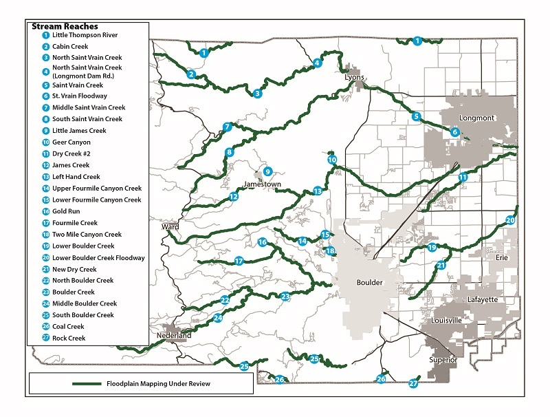
Boulder County, Colo. - Following the 2013 Flood, the state-funded Colorado Hazard Mapping Program (CHAMP) has been re-mapping the regulatory floodplain of the most affected waterways in Colorado.
In July 2023, the Federal Emergency Management Agency (FEMA) released revised Preliminary Flood Insurance Rate Maps (FIRMs) based on the CHAMP data and subsequent appeals. FEMA is now in the final stages of incorporating the CHAMP study into the effective FIRMs. We expect FEMA to update the effective FIRMs in the summer of 2024. FEMA uses Flood Insurance Rate Maps (FIRMs) to determine who is subject to the flood insurance mandatory purchase requirement.
At the same time, the county is planning to update and align the Boulder County Floodplain with the revised Preliminary FIRMs. Visit boco.org/FloodplainRemapping to view the effective and proposed FEMA and Boulder County floodplains.
The proposed changes only apply to unincorporated Boulder County, not in cities or towns in Boulder County.
Boulder County is hosting an informational meeting where the public can learn about the upcoming changes to floodplain maps, ask questions, and submit comments.
What: Informational Meeting on Upcoming Changes to Boulder County Floodplain Maps
When: Wednesday, Dec. 13 from 6-7 p.m.
Where: Virtual meeting via Zoom. Register to attend at boco.org/z-23-0001
Registration is required, but participants can register at any time, including after the meeting has started. Participants may also call-in to the meeting by dialing 1-833-568-8864 and entering the meeting ID 161 469 5580. The meeting will be recorded and posted online.
A separate in-person meeting will be held for residents of Lefthand Creek between Geer Canyon and 49th Street. These residents will be impacted by a partial re-study of Lefthand Creek. Affected property owners should have received a postcard with the meeting details, although the meeting is open to the public. The meeting will be held in-person at the Boulder County Parks & Open Space office at 5201 St. Vrain Road on Thursday, Nov. 30 starting at 6 p.m.
Next Steps
Staff will accept comments on the proposed zoning map amendments through the end of December before taking the docket to the Boulder County Planning Commission in 2024. Subscribe to receive Planning Commission agendas to see the commission’s agendas and register to speak at meetings. Pending a recommendation from the Planning Commission, staff will then present the docket at a public hearing before the Board of County Commissioners. Check the Docket Z-23-0001 website for future hearing dates.
Questions about the Floodplain Remapping project and the upcoming meetings can be directed to Kelly Watson, Principal Floodplain Planner, by email to FloodplainAdmin@bouldercounty.gov or by calling 720-564-2652. Visit boco.org/FloodplainRemapping to learn more.