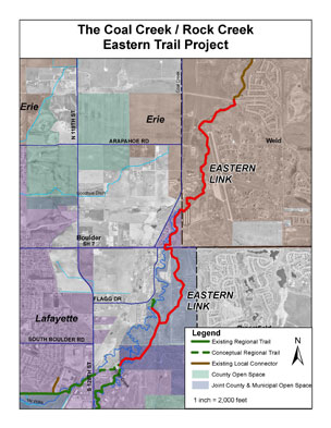
This section of the Coal Creek Regional Trail, completed in 2013, adds 4.0 miles of multi-

Coal Creek/Rock Creek Easter Trail Link Project
use trail that extends from the terminus of the Rock Creek Regional Trail near Majestic Drive in Lafayette to Erie’s Spine Trail near Vista Parkway. The entire Coal Creek and Rock Creek trail system will be 27 miles connecting the communities of Boulder, Superior, Louisville, Lafayette, Erie and Broomfield. The last 1.2 miles slotted for completion are located near U.S. Hwy. 36 within the City and County of Broomfield.
Construction of the trail cost just over $1.4 million, with funding provided by the three project partners (Boulder County, the City of Lafayette and the Town of Erie) and by a $500,000 Special Opportunity Grant by Great Outdoors Colorado.
Description
The Eastern Link is approximately four miles long, with a crusher fines surface with bridges spanning Coal and Rock Creeks and an underpass at SH 7. It completes the entire Coal Creek trail and nearly the entire Rock Creek trail.
The trail traverses through open space property jointly owned by the City of Lafayette and
Boulder County known as Two Creeks Open Space. It also passes through right-of-way owned by the Colorado Department of Transportation, property owned by the City of Lafayette and the Town of Erie.
Funding
Boulder County worked with the Town of Erie, City of Lafayette, the Boulder County Parks and Open Space Foundation and Great Outdoors Colorado (GOCO) to secure funding to complete the eastern most link of the Coal Creek/Rock Creek Regional Trail System. GOCO awarded a $500,000 grant through its special opportunities program which allows for larger grant awards for larger scale projects. Boulder County Transportation is using dedicated funds for trail implementation passed by Boulder County voters in 2001 and extended in 2007.
Project Contact
Tonya Luebbert
Regional Trails Planner
720-564-2866
tluebbert@bouldercounty.gov

