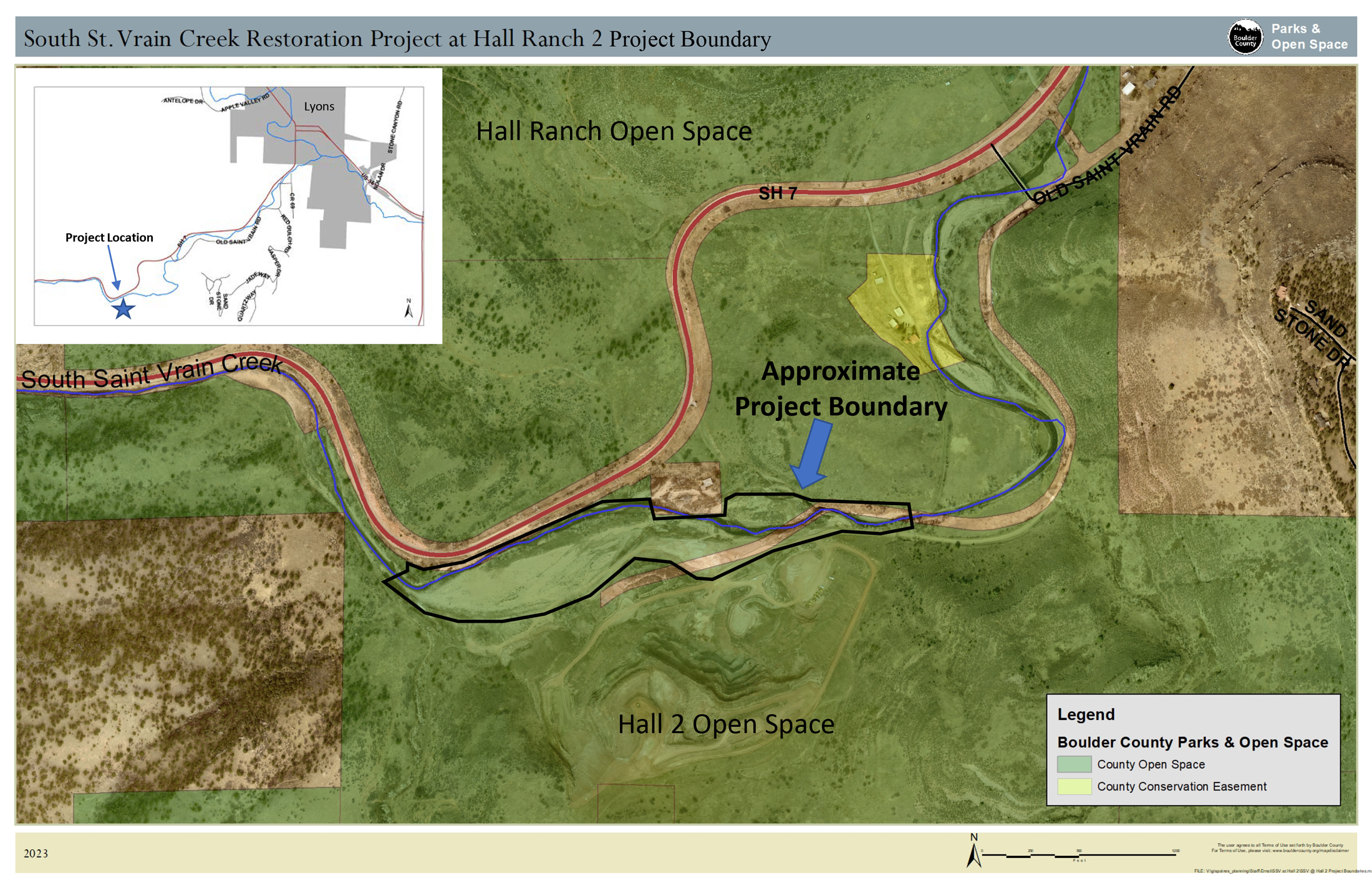
Boulder County is proposing to restore a section of the South St. Vrain (SSV) Creek on the Hall Ranch 2 open space property. The project presents a valuable opportunity to reconnect the creek to its historical floodplain, allowing the creek to function more naturally with minimal risk to infrastructure. An 80% design was completed at the end of 2024, and Boulder County is currently working to secure funding and permits. Construction is targeted for fall of 2027.
South St. Vrain Creek Restoration Project
Goals and Objectives
The goals for the project are to restore and improve the channel and surrounding floodplain to protect life and property, and provide a safe, natural, resilient, functioning, and ecologically rich habitat utilizing natural system principles. The project will address past disturbances and enhance the area’s resilience to future flood and fire events.
The project will realign the historically manipulated SSV Creek mainstem channel to a more natural course, increase floodplain connection, improve flow conveyance and sediment transport, and provide resilient and ecologically rich habitat.
Project Components
- Realignment of the SSV mainstem channel to a more natural course
- Incorporating natural channel diversity and function
- Re-establishing floodplain benches for lateral connectivity
- Improving flow conveyance and sediment transport processes
- Promoting naturally functioning stream processes
- Protecting public and private infrastructure
- Improving public safety
- Repairing unstable erosion scars in high-risk areas
- Revegetating denuded areas with a diversity of riparian, wetland, and upland native species
Floodplain Reconnection Benefits
- River health
- Improved fluvial and ecological processes
- Fish and wildlife habitat
- Water quality enhancements
- Open space benefits
- Natural flood protection for downstream infrastructure
Design
The project will involve extensive mass grading to realign the creek channel to the center of the valley and reopen the floodplain and overflow channels. It will also include brush trenches and native vegetation to increase channel roughness and improve habitat.
The design aims to deliver targeted benefits without interfering with the creek’s natural evolution. Channels are being designed to resist lateral migration and avulsion during a 1.5-year recurrence interval discharge. The design allows for natural adjustment over time, especially during larger flood events, and includes strategic resistive treatments to help strike this balance.
Boulder County is working with Stillwater Sciences and their team (HDR, Inc., Alpine Ecological Resources, LLC, Johnson Environmental Consultants, and Boulder Land Consultants) to advance the existing 30% design plans through final design to a construction-ready 80% design package.
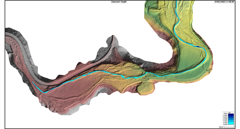
Hydraulic model results for the current condition at baseflow (16 cubic feet per second) showing the creek channelized along highway
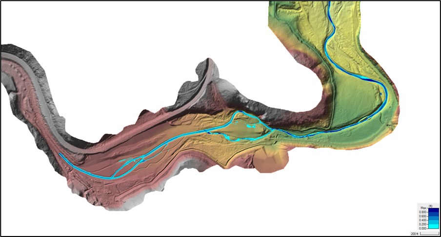
Hydraulic model results for the proposed condition at baseflow (16 cubic feet per second) after the realignment of the creek into center of floodplain
Features
- Extensive mass grading to create a new floodplain and channel realignment into the middle of the valley with approximately 53,000 cubic yards of cut and fill
- Installation of woody brush trenches to increase floodplain roughness and habitat diversity
- Several small, simulated beaver structures will help create a complex floodplain
- Additional grading to open floodplain benches
- Extensive revegetation using native species with soil conditioning as needed
- Filling the existing channel alignment and securing it from future avulsion risks
Timeline and Cost Estimate
Boulder County and the Stillwater team finalized the 80% design package at the end of 2024. Boulder County is currently working to secure funding and permits. The Stillwater team is assisting with permitting the project. Boulder County would like to put the project out to bid by early 2027 with a construction date targeted for fall of 2027. The current cost estimate for project construction is approximately $4.5 million.
Background
Over the past century, SSV Creek in the project area has seen many changes. It was once a natural, meandering, alluvial creek at the base of the South St. Vrain canyon that captured flood waters and sediment and provided important habitat for a variety of species. Historic aerial photos from 1953 show the alignment of SSV Creek naturally meandering through pastureland with a thick line of riparian vegetation and Old St Vrain Road tucked up against the south side of the valley.
Highway 7
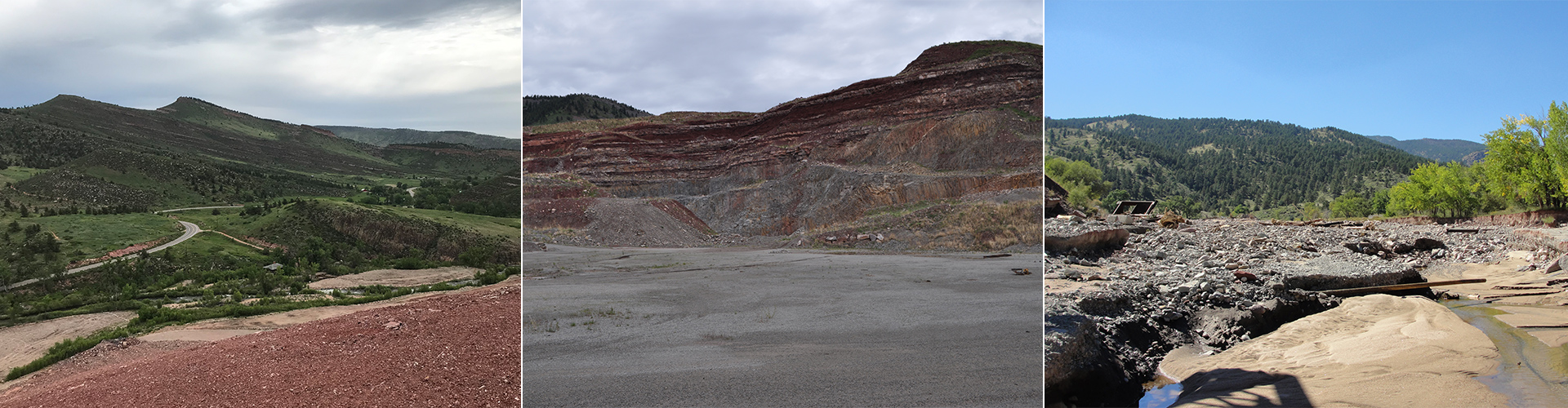
In the late 1950s, Colorado Highway 7 (CO-7) was built on the north side of the valley floor and began to encroach slightly on the creek channel. The largest impacts to SSV Creek began in the 1960s due to mining activities at Lyons Quarry. The creek was moved up against CO-7 and channelized, most likely to make room for excavation in the floodplain as a staging area. The straightening of the channel greatly reduced riparian habitat, increased channel slope, and created an over-steepened channel section that still exists today.
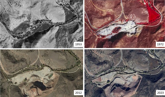
A series of historical aerial imagery of the project site from 1953, 1972, 2012, and 2023 showing the significant disturbance the area has experienced in recent history including the construction of State Highway 7, mining, and the realignment of South St. Vrain Creek.
Lyons Quarry Mine
Mining operations on the south side of the creek also caused significant impacts. Equipment and vehicles were used for decades across the floodplain, compacting soils and spreading quarry materials. Spoils were filled on river right creating a valley pinch that still exists today.
While recent mine reclamation efforts have led to some improvement in floodplain conditions, the creek channel lies outside the permitted mine area and was not addressed in the Lyons Quarry Reclamation project.
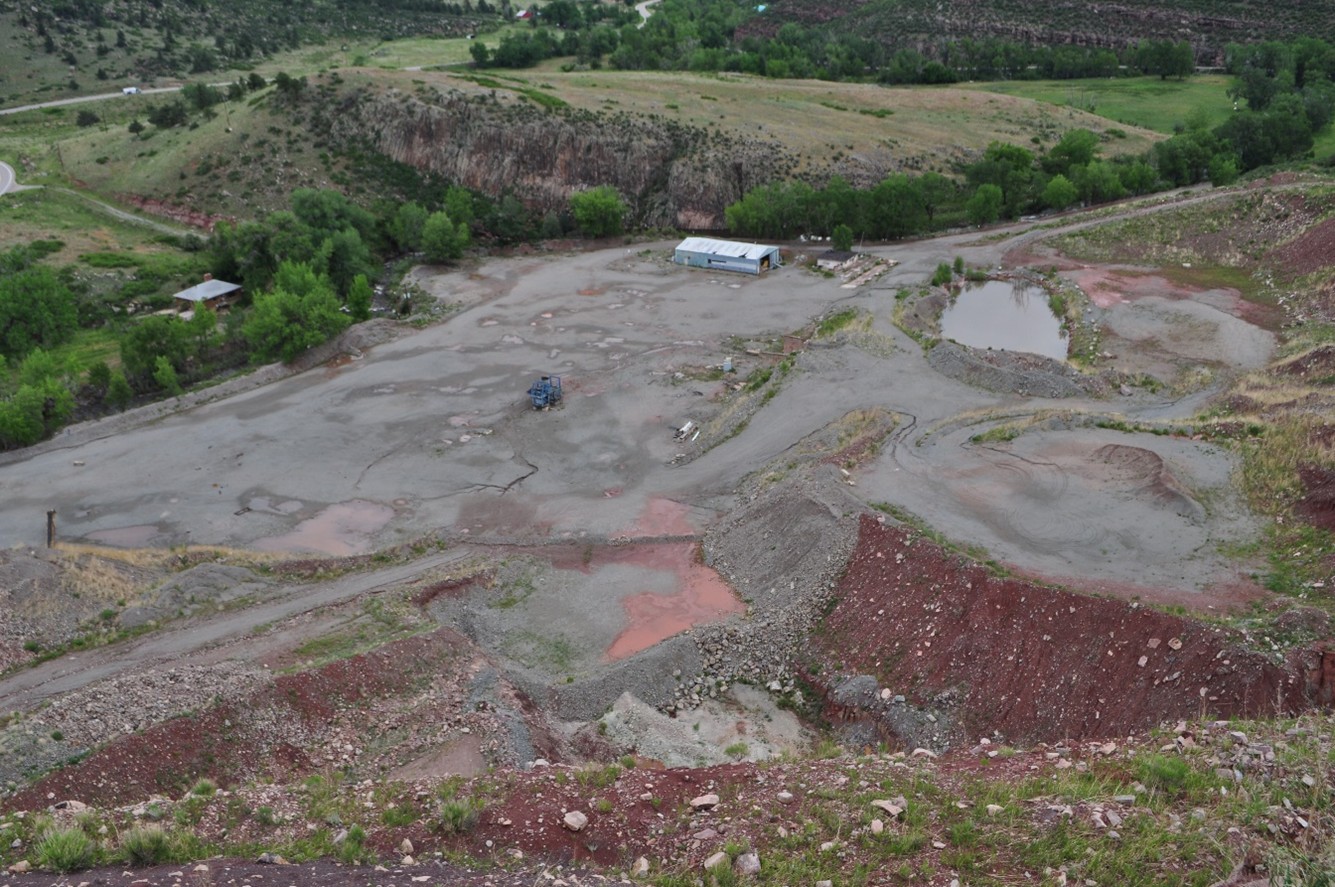
View of the project site taken in June 2011 from the top of Lyons Quarry, looking northeast and showing the impacts of mining on the floodplain.
2013 Flood
The 2013 flood wreaked havoc by depositing flood debris across the site and creating a channel avulsion in the middle of the reach, which shortened and steepened the channel profile. Much of the debris has been removed, but the avulsed channel still exists.
The St. Vrain Creek Coalition, Boulder County, and other stakeholders identified restoration of SSV Creek at the Hall 2 site as high priority. The St. Vrain Creek Watershed Master Plan was created and designated the project area as Tier 1 – Projects reducing flood risk due to post-flood conditions.
The county secured Community Development Block Grant – Disaster Relief funds and completed a 30% creek restoration design project (see above) for a 3.2-mile reach of SSV Creek, including the Hall Ranch 2 property. Although a 1.5-mile reach of the SSV Creek further downstream received NRCS Emergency Watershed Protection funds to implement restoration efforts, this project area did not receive funds and was put on hold until active mining and reclamation operations reached completion.
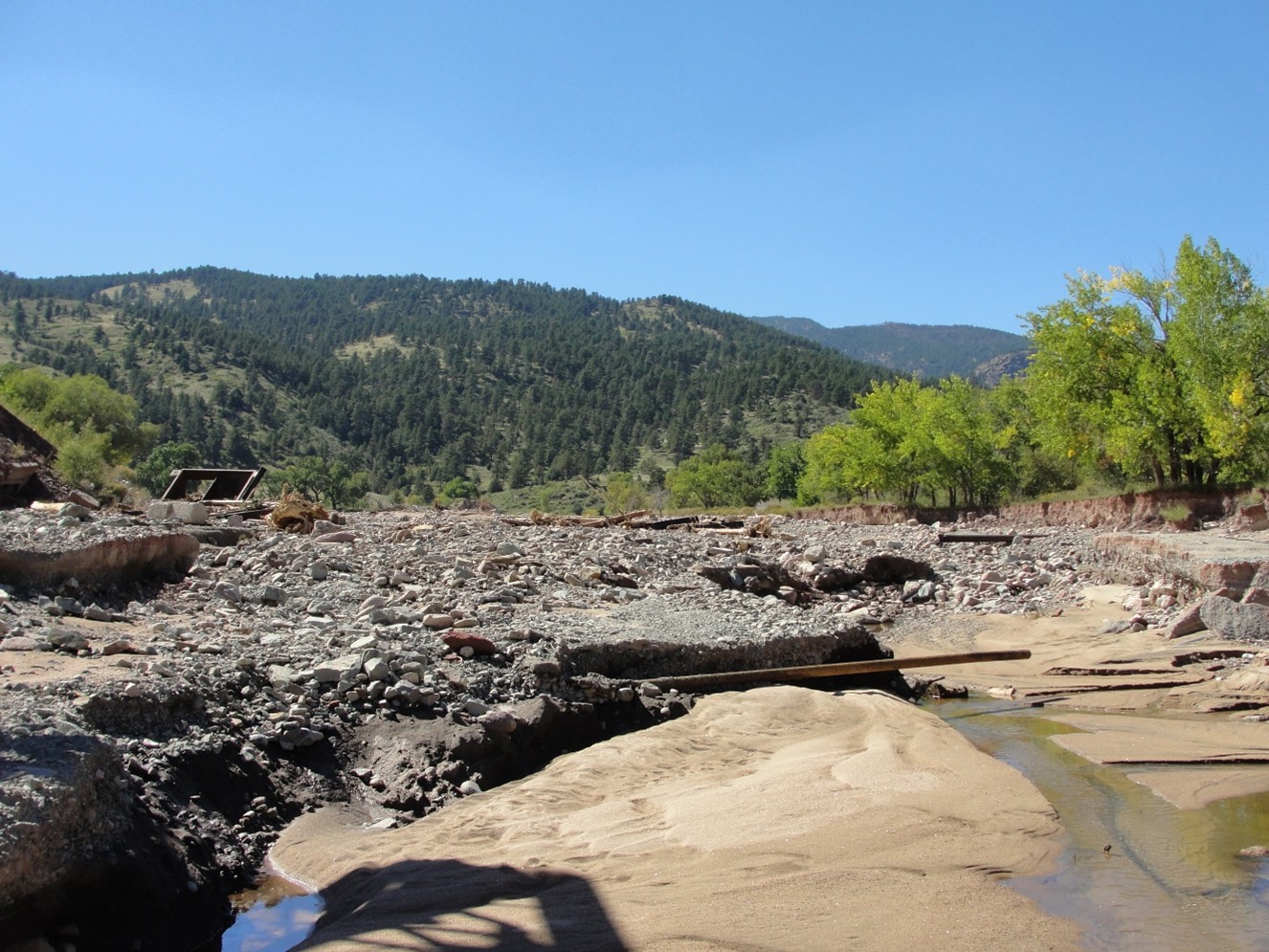
View of flood impacts in September 2013 taken from the east end of the project site looking west.
Public Engagement
During the development of the 30% design, Boulder County and their consultants hosted six public meetings, one site visit, and had numerous other points of contact with community members, to gather public input about the goals for the corridor, site history, existing conditions, issues and concerns, project alternatives, and ultimately, the preferred alternative. In addition, Boulder County and the consultants met individually with each landowner in the 3.2-mile corridor (of which the 0.7-mile Hall 2 reach is a part) to hear their interests, ideas, and concerns regarding their properties. Almost two hundred comments were collected during this process.
Based on these public contacts, as well as information provided by Boulder County on public comments received between September 2013 and May 2016, the 30% design team developed an issue-based decision-making process that led to the development of the preferred alternative and 30% design plan.
Contact Us
Parks & Open Space
Ernst Strenge
estrenge@bouldercounty.gov
303-678-6269