Read the commissioners’ update about Xcel’s Power Outage.

Lyons Quarry Reclamation
Lyons Quarry

Lyons Quarry Reclamation at Hall 2 Open Space

Holcim-WCR, Inc., formerly known as Aggregate Industries, began reclamation of the Lyons Quarry at Hall 2 Open Space in fall 2021. Mining and reclamation occurred under a permit issued by the State of Colorado’s Division of Reclamation, Mining, and Safety (DRMS). Although the property is owned by Boulder County as open space, the quarry and its subsequent reclamation requirements are under the jurisdiction of DRMS, and Holcim-WCR, Inc. is solely responsible for the reclamation project and operations.

Reclamation Plan

Holcim-WCR, Inc. has coordinated and worked with Parks & Open Space since the county purchased the property in 2011. Since that time, the county, as landowner, has provided comments and recommendations to Holcim-WCR, Inc. and DRMS, but DRMS provides the ultimate oversight and approval of the mining and reclamation permit and work.

The final reclamation plan calls for:

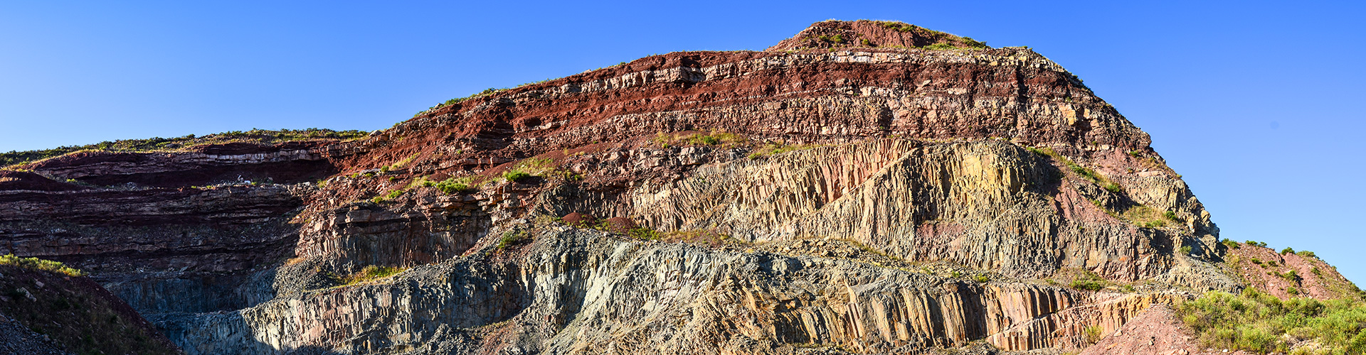
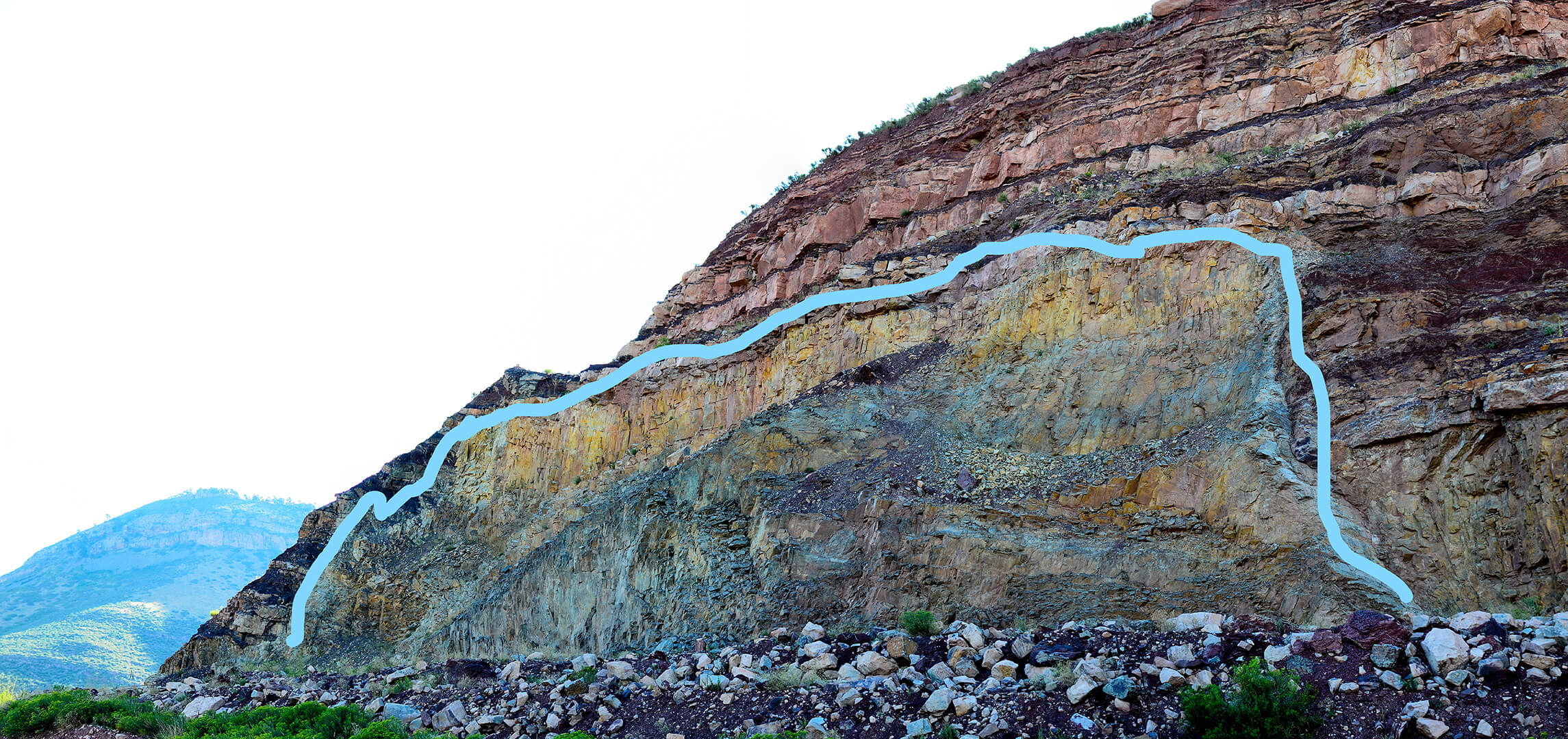
  • Regrading the “high wall” (i.e., steep portions of the quarry) to mimic the natural slope of the surrounding landscape through minimal blasting and earth moving.
  • Preserving a section of the exposed dacite walls at the base of the mine for geological interpretation purposes. Dacite is a type of granite. This hard rock has intruded, or pushed through, softer rock throughout the Rockies, creating our magnificent mountains. At this site in particular, the granite has intruded into the sandstone. You can see this in the exposed rock where sandstone is found both above and below the dacite. Local geologists believe this is the terminus of the “mineral belt” of hard rock where gold, silver and other ore are mined from SW Colorado to Lyons.
  • Removing crusher fine material from the floodplain and along South St. Vrain Creek.
  • Constructing rockfall catchment areas at the base of the highwall.
  • Scaling and stabilizing the remaining highwall slopes.
  • Installing stormwater drainage and erosion control infrastructure.
  • Conditioning soil and planting native vegetation adapted to the site conditions.
Andesite intrusion between layers of sandstoneAndesite intrusion between layers of sandstone

Lyons Quarry Plan

Features

Features of the reclaimed site will include:

  • Reclaimed and stable slopes.
  • Exposed rock/dacite wall providing a geological feature for education, as well as habitat for cliff dwelling species.
  • A diverse assemblage of native vegetation.
  • Public access outside the mine footprint as defined by/approved by future management planning process.

Site Impacts & Timing

  • All reclamation work will occur within the current footprint of the existing mine to avoid impacts to adjacent undisturbed habitat.
  • Reclamation work began in September 2021
  • Grading, site stabilization, and revegetation are anticipated to be completed by summer 2023.
  • Following regrading and revegetation, Holcim-WCR, Inc. will be required to monitor and maintain the site for several years including weed control, monitoring site stability, and establishing native vegetation, to ensure the site is stable and the revegetation efforts are successful.
  • Before Holcim-WCR, Inc. can be released from their reclamation bond, the site must meet the following DRMS requirements:
    Rule 3.1.10(1) In those areas where revegetation is part of the Reclamation Plan, land shall be revegetated in such a way as to establish a diverse, effective, and long-lasting vegetative cover that is capable of self-regeneration without continued dependence on irrigation, soil amendments or fertilizer, and is at least equal in extent of cover to the natural vegetation of the surrounding area.
    (from Minerals Rules and Regulations of the Colorado Mined Land Reclamation Board for Hard Rock, Metal, and Designated Mining Operations (2019)

Lyons Quarry Map

South St. Vrain Creek Restoration at Hall 2

Over 50 years ago, an approximately half-mile reach of South St. Vrain was channelized along the south side of State Highway 7 on what is now the Hall 2 Open Space property. An aerial photograph from 1940 shows the natural alignment, which had more natural meanders across the floodplain. Because the channelization was not part of the mining plan for Lyons Quarry, it was not included in the mine reclamation permit and is outside the permit boundary. Therefore, the mining company is not responsible for its reclamation.

Since 2011, Parks & Open Space has envisioned realigning the creek to its natural alignment. The post-2013 flood assessment, planning, and engineering supported this vision. A 30% restoration design plan for the site was completed in 2016 as part of the 2013 flood recovery efforts. This plan shows the creek being realigned and restored into its natural meander using natural channel deign principles and the construction of overflow channels.

Parks & Open Space plans to finalize the creek restoration designs in 2023. The timing of construction is dependent on how soon the area is successfully reclaimed and released from its reclamation bond by DRMS. In addition, funding for the restoration work is still pending, but the department hopes to complete the work prior to future public access.

The project will improve resiliency by increasing the floodplain connectivity and providing areas for flood waters and sediment to spread and settle out during high flow events. It will also improve the habitat quality by providing in stream features, such as riffles and pools and large woody debris, as well as improve and increase the wetland and riparian habitat. Finally, realigning the creek will provide better access for potential future public use pending the outcomes of the management planning process.

Aerial photo of the Lyons Quarry area showing the creek had a natural, meandering alignment before it was changed to the current channelized alignment

Future Open Space Planning at Hall 2

Parks & Open Space will not have full management authority of the property until Holcim-WRC, Inc. has successfully reclaimed the Lyons quarry and DRMS releases the mine’s reclamation bond. To help determine the best uses of the property, the department wants staff and the public to have a good view of what the post-reclamation landscape will look like before starting a planning process.

At that time, Parks & Open Space staff will conduct a public planning process to determine the future management direction for the Hall 2 open space property. This property is part of the larger North Foothills open space complex which includes Hall Ranch and Heil Valley Ranch. The site has the potential for many unique opportunities for recreation, appropriate public amenities, education and interpretation, and the conservation of significant natural resources.

History

The site has been mined by various operators since the 1950s with most of the active mining occurring between 1977 and 2008 under DRMS permit M-1977-141. Although the site was under a five-year “temporary cessation” between 2011 and 2016, whereby the mining company was allowed by DRMS to postpone all mining and reclamation activities, the company continued to revise their reclamation plan and met with Parks & Open Space staff several times to hear about the department’s interests and long-term plans for the site.

The 2013 flood did a lot of damage in the mine’s floodplain and washed out the county bridge across South St. Vrain Creek, which had previously provided access to the quarry.

Starting in 2017, after the bridge was repaired by Boulder County and the temporary cessation had ended, the mining company began to finalize their reclamation plan and has continued to work with Parks & Open Space as they further revised and implemented their reclamation plan.

Contact Us

Parks & Open Space

Ernst Strenge
estrenge@bouldercounty.gov
303-678-6269