South End:
Why was the decision to move ahead with both design options?
The design team presented two design options for further consideration to the public in May 2026 (see graphic). Feedback from the public indicated the best connectivity for all users would be to provide both alternatives.
- The new underpass option flows better, is safer, and offers a more direct route for cyclists traveling southbound or northbound for Dakota Ridge.
- Survey responses and comments from the public meeting noted that the option running along Old Broadway feels safer and more direct for those heading northbound toward Lyons.
How much more will it cost to construct both options?
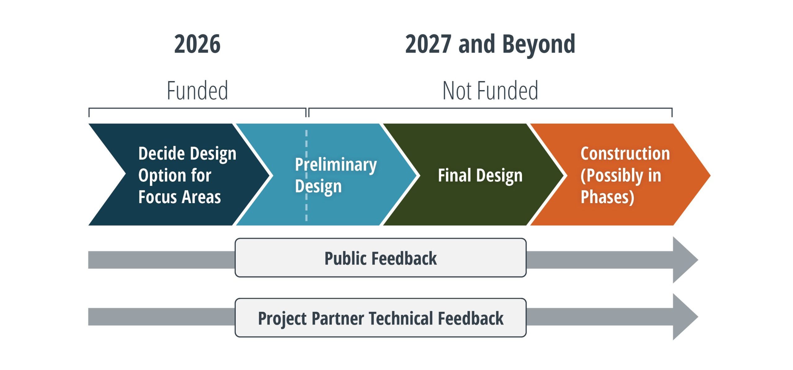
As of now, neither option is funded. The county is actively pursuing grant funds for construction. The design team is proceeding with designing both, but the priority will be to construct the option that runs along Old Broadway and add the underpass if funds become available.
The design option that runs along Old Broadway is the cheaper of the two to construct. Construction of the underpass option including the additional bikeway leading to and from the new underpass does add about $2 million.
Why not use the existing underpass between Old Broadway and the westside of US 36?
The design team and our partners at City of Boulder Open Space and Mountain Parks carefully weighed this option but this would require a section of bikeway to be constructed in wetlands between the existing underpass and the City of Boulder. The existing underpass is in poor condition, has poor drainage and is undersized to accommodate the bikeway so the existing underpass would have to be replaced.
Connection to Lefthand Canyon Drive:
Why was the at-grade crossing to Lefthand Canyon Drive chosen?
Public feedback and technical input from the partners and the bikeway design engineers revealed several formidable issues with using the existing bridge over Left Hand Creek as an underpass.
- The creek and riparian area along the creek are heavily used by wildlife.
- The bikeway would be flooded in high water conditions with no suitable detour.
- Limited CDOT owned land or other public lands to connect the underpass to Lefthand Canyon Drive.
- The underpass option would require a mid-block at-grade crossing on Lefthand Canyon Drive for cyclists biking up the canyon.
The at-grade crossing would allow for the most cyclists movements to and from the bikeway to Lefthand Canyon Drive and Plateau Road. It was favored by some of the survey respondents.
Unlike the other priority areas, preference for the Lefthand Canyon Drive design options varied greatly by gender and biker confidence level. When considering all survey responses, the difference in preference is less than 2.5%, with a small majority preferring Crossing Under the Existing Bridge.
- 59% of Female respondents preferring the At-Grade Crossing. Females who chose the at-grade crossing did so citing safety (with upgraded crossing infrastructure), reduced environmental impact to wildlife and wetlands and affordability.
- “Highly Confident” cyclists also prefer the At-Grade Crossing
Intersection of US 36 and CO 66
Why was there only one design option for the US 36/CO 66 intersection shown to the public when other focus areas had at least two design options presented to the public?
The bikeway design engineers explored the bikeway crossing under the existing bridge but there is not enough CDOT or other publicly owned land to do this. To get the bikeway from the road to down under the bridge, the bikeway needs adequate distance to remain at a reasonable grade (under 5%). To achieve this, the design team considered multiple alignments including crossing on the south side of the creek and on the north side. None of the alignments could achieve reasonable grades without needing easements from private property owners. Due to these challenges, an at-grade crossing that includes numerous safety improvements was selected. Improvements include refuge islands with raised crossings, more visible pavement markings, and revised right turn lane from CO 66 to US 36 that would slow down drivers, all these additions would improve safety and connectivity for bikeway users in all directions.
What are the criteria being used to determine crossing types at each priority location? How was the preferred alignment selected?
Input from the following groups have all aided the decisions for crossing types: CDOT, City of Boulder Open Space and Mountain Parks and Transportation and Mobility, County Parks and Open Space and Public Works, Town of Lyons, public feedback from May 2026 open house, meetings with cycling safety advocates, a 12-member community advisory committee.
Other considerations and constraints were CDOT owned land or other public lands, avoiding or minimizing impacts to rare plants, wetlands, and wildlife, not decreasing shoulders and additional design features that would increase safety for motorists on the road.
The bikeway design engineers followed the Manual on Uniform Traffic Control Devices, a book created by the Federal Highway Administration that is the law of national standards and the Public Right-of-Way accessibility Guidelines, which are federal requirements, The design team also incorporated Boulder County’s Multimodal Standards and best practices in recent bikeway construction in the west.
Why is Boulder County prioritizing this project?
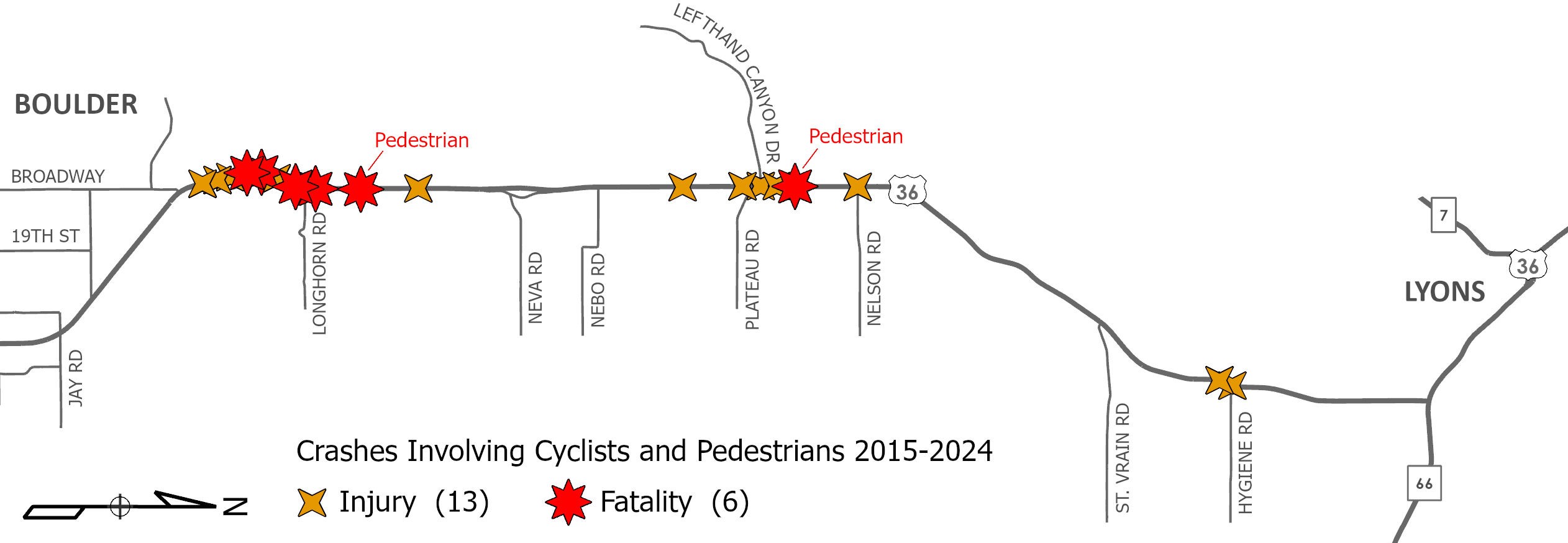
There are more crashes involving cyclists and pedestrians on this road than any other road in the county. In the ten-year period of 2015 to 2024 there were 13 injury crashes involving cyclists or pedestrians and six fatalities involving a cyclist or pedestrian along US 36 between Broadway in Boulder and the CO 66 intersection.
The CDOT bike counter shows that more than 52,000 cyclists ride this road per year. Other cyclists that want to ride on this road choose not to because they feel unsafe. People driving this road have reported that passing cyclists is stressful and difficult.
How will the bikeway accommodate both recreational riders and experienced/high-speed cyclists?
The bikeway is designed to be 12-foot wide with as few turns as possible. Similar to the existing US 36 bikeway which is also 12-foot wide. This width gives passing room for cyclists.
Will there be frequent stops or sharp turns on the bikeway?
Public feedback was clear that frequent stops or sharp turns on the bikeway would be intimidating for the interested but concerned riders and would dissuade the confident riders from using the bikeway. The design team has only included turns or stops where absolutely necessary and has made any needed turns as wide as possible.
Will the bikeway project improve the bus service on the route?
The Lyons Flyer has stops on US 36 between Lyons and Boulder but, the stops are indicated by a sign with no platform or a safe or comfortable place for bus riders to wait. There are also no marked crossings to cross US 36 to access the bus stops. The project includes constructing an actual bus stop. The planned at-grade bikeway crossing at Lefthand Canyon Drive will also serve as safety improvements for people crossing to and from the bus stops.
Will wildlife underpasses or crossings be included as part of the project?
The bikeway project staff and the Parks and Open Space wildlife project staff are working closely together to design compatible and complementary projects. Click here For more information on the wildlife crossings project. The bikeway design team is coordinating Parks and Open Space so the two projects can strengthen and enhance each other.
How will wetlands, rare plants, and sensitive habitats be protected?
The design options were carefully planned to avoid wetlands, sensitive habitats and rare plants. In the few small areas where there could be impacts, mitigation measures will take place. Mitigations that have been used on similar projects include re-establishing wetlands, and re-planting rare plants in other suitable environments.
This bikeway is designed to increase safety for all without compromising the unique and protected environmental resources surrounding it.
Will cyclists still be able to use the road shoulders when the bikeway is built?
While the bikeway is being designed to encourage use by all types of cyclists, cyclists will not be legally prohibited from riding on the US 36/North Foothills shoulder.
In a 2024 bikeway survey, over 75% of respondents who currently ride on the shoulder said they would ride on the bikeway once it is built. In the same survey, 93% of those that do not currently ride on the shoulder reported that they would ride on the bikeway once it is built.